|
Web Map Designer
Introduction
 GIS and web technologies have advanced in recent years to allow the sharing of geospatial
data on the web. The number of map servers available to the public is
increasing every year. There is a need for simple and inexpensive tools for
accessing these map services and creating maps for web sites. The open source
mapping software called OpenLayers provides a rich set of tools for building
custom map clients within a web browser using JavaScript.
GIS and web technologies have advanced in recent years to allow the sharing of geospatial
data on the web. The number of map servers available to the public is
increasing every year. There is a need for simple and inexpensive tools for
accessing these map services and creating maps for web sites. The open source
mapping software called OpenLayers provides a rich set of tools for building
custom map clients within a web browser using JavaScript.
Basic Design
Kingbird Software has developed a thin map client running in a web browser utilizing JavaScript and open source
components such as OpenLayers,
GeoExt, and
Ext JS. No software
installation or plug-in is required to display the map, and all major browsers
are supported.
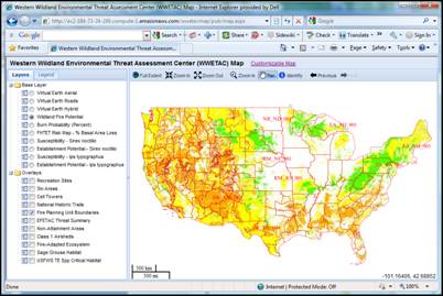
Capabilities of the Map
- A toolbar including the following tools:
- Full Extent Button. Zooms to the full extent of the map.
- Zoom In Button. Zooms in on the map.
- Zoom Out Button. Zooms out on the map.
- Zoom In Tool. Draw a rectangle on the map and zoom to the extent of the rectangle.
- Pan Tool. Click and drag the map to change the viewable area.
- Identify Tool. Click on the map and retrieve information for that point location. A small
resizable and movable window will display information on the clicked
location.
- Previous Button. Changes the extent of the map to the previous extent displayed before the
last pan or zoom operation.
- Next Button. Changes the extent of the map to the next extent in the list. This button is
only enabled when the Previous Button is used. This allows you to move
back and forth between the extents you have chosen.

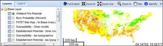
- Spatial reference is EPSG:4326 (latitude/longitude based
on the WGS84 datum). This spatial reference supports adding additional
layers from non commercial map servers. This is the most widely supported
spatial reference system for non commercial providers.
- Requires a login in order to access the map. The login
allows the system to save and retrieve your custom map. The login is not
used for security or commercial purposes. The only information required
is a username, password, and email.
- Standard map navigation using the mouse wheel to zoom in
and out, and click-drag to pan the map.
- A map scale displayed in both miles and kilometers in the
lower left corner of the map.
- The map coordinates of the current mouse position are
displayed in the lower right corner of the map in latitude and longitude
units.
- Layers list and legend can be resized and collapsed to
increase the map area.
- The Layers / Legend window is located to the left of the
map display area. This window has a tab interface that allows you to
switch between the layers view and legend view.
- The layers list allows you to select which layers will be
displayed in the map.
- The dynamically generated legend will display layer
symbols for layers that are currently displayed in the map. The legend
symbols are downloaded from legend graphics published on WMS map servers
according to OGC standards. Note that legend symbols are dependent on
published graphics and are therefore not available for all layer types.
Customizable Capabilities
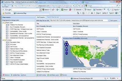
- Access a separate web browser page with tools for
customizing the map from a button above the map.
- Search for web map servers and layers by a user specified search term.
- Preview layers before adding them to the map.
- Add layers from any OGC compliant web map service.
- Remove layers from the map.
- Reorder the layers.
- Specify the default visibility of the layers.
- Update the map with changes.
- All changes made to the map can be saved for future sessions.
Obtaining a copy of the map client
The existing map
client was developed for the US Forest Service and is available for free on their website.
Software Development Services Provided
Custom software development services are provided to further enhance or customize the existing
map client to suit the needs of various users. In addition, we offer
open source map server cloud hosting
to serve your GIS data on the web.
|